Over 150 Revit Architecture and SketchUp designs featuring Georgia-Pacific Gypsum products available for BIM models
Georgia-Pacific, one of the world’s largest manufacturers of building products and paper, wants to simplify 3D design for architects, designers and contractors.
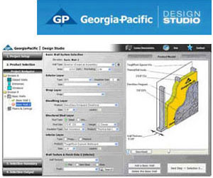
The Atlanta-based company’s G-P Gypsum LLC division said Thursday it added over 125 downloadable files built in Autodesk’s Revit (.RVT) design software and 23 files built in Trimble Navigation’s 3D modeling software SketchUp (.SKP) to its online portal for the design and construction industry, called Design Studio.
The .RVT and .SKP files comprise a selection of commercial assembly designs – wall assemblies, floor/ceiling combinations, area separation walls, shaftwall assemblies – built using products from G-P Gypsum including: DensArmor Plus Interior Panels, DensGlass Sheathing and Shaftliner, DensShield Tile Backer, ToughRock Gypsum Boards including ToughRock Mold-Guard and ToughRock Abuse-Guard; and Fireguard and Fireguard C panels.
The files can be downloaded or imported into Revit or SketchUp for Building Information Modeling (BIM) models. Other online design tools available from the G-P’s Design Studio, include:
- Assemblies Library – database of information, illustrations and performance characteristics for wall systems and assemblies using G-P Gypsum products
- CAD Drawings – 2D CAD details of assemblies, available in multiple formats
- LEED Calculation Tools – concise information about a product’s potential LEED credit contribution in the U.S. and Canada
- Online Architectural and Roofing Binders – Division 9 and Division 7 compilations of specifications, working documents and case histories
- Residential Wall Systems Comparison Tool – for examining and comparing recommended pre-configured wall systems in five climate zones based on fundamental performance